Venture to the Wallowas (Aug 6-9, 2018)
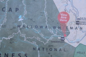 Early-Mid August Munchmix and I ventured from Joseph, Oregon into the Wallowas via the Tenderfoot Trail. To say we got a late start is an understatement. To say the road to the trailhead was rough is also an understatement. We tottered along in the Prius about 5-8mph for about 5 miles finally arriving, loading up our packs and setting out at about 6pm. Tenderfoot Trailhead sits at 6,480 ft. Trailhead amenities include a sign board with map and a DIY hiking permit to fill out and carry along. That’s it. We hiked a couple miles setting up camp before the crossing of the North Fork of Big Sheep Creek. Creeks were flowing but it was otherwise dry. Creek crossings were pretty easy with a log here or a series of step stones there. There were just enough mosquitoes to remind you it wasn’t too bad. Evening held a slight breeze and a fleece was just enough for the chill.
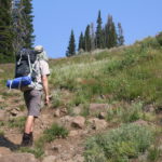 About 8am we set out with the scent of forest fire in the air and a bit of smoke shrouding the mountain views. Fires were in Idaho with the wind drifting our direction. Along the way, wildflowers were in bloom though likely late season flowers. We wouldn’t expect much left in another week or two. The day warmed quite a bit and we enjoyed a shady break on a log by Lower Bonnie Lake (7760 ft.) There was lots of bird activity and midges dancing over the water surface but none bothered us.
After a quick side peek at Upper Bonnie Lake, we continued our way to Dollar Pass (8,400 ft.) Along the way there were just enough spring creek crossings for easy water filtering breaks. We set up camp on the south side of Dollar Lake in view of a melting 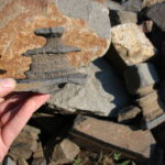 snow field and near clumps of willows. By afternoon a snow melt creek was babbling along giving us an easy place for water filtering. By evening there were a few more mosquitoes, but a light breeze kept them mostly at bay. Scrambling out on a large rockfall area we noticed very unusual rocks. These were sedimentary but some layers seemed like solid igneous rock. The more sandstone-ish layers were heavily eroded creating sculptures of broad and skinny bands.
Next morning we left camp in place to spend the day exploring–it seemed the smoke in the air had cleared most areas, except the view to Joseph remained completely obscured. We ventured over the saddle from Dollar Lake on a user trail over the Tenderfoot Pass (8,500 ft.) and over to Jewett Lake. We passed one pink snow field on the way…bacteria. You could see as evaporation had progressed, two shallower sections of Jewett Lake had divided of into large ponds; the lowest one a favorite with the birds. We soaked our feet in Jewett Lake for a few minutes watching several immature newtes scurrying about the bottom and dozens of caddis fly larvae. We spotted one lone mountain goat far above on the rock scree. We looked for companions but found none. From there we crossed Tenderfoot Pass and at first, took a small goat trail up the side of the ridge. Within a tenth of a mile it blended into the rocks and was gone but lead us through a beautiful wildflower slope. We worked our way back down the slope and headed south on trail 1814 along the Imnaha divide. As we traveled, we noted the smoke dropping back into the valleys again.
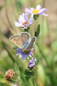
The day became hot quickly and shade breaks were appreciated when we found them. At the map-noted spring crossing, we ventured up stream to the source–a pool bubbling up from the ground into the blazing sun. In the surrounding mud, butterflies gathered to sip their mineral tea. Now off 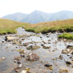 trail, we walked on to the source of the second spring–a truly impressive gush of water coming up from the ground and creating a small surrounding wetland. At this point we began the steep off-trail ascent up the side of the Imnaha Divide. This would take us to 9,000 feet. Part way, during a break under a clump of trees I spotted a beautiful shell print fossil. Upon showing it to Munchmix, we both had solid search imaged and discovered we were surrounded by fossils. It was impossible to not see them—everywhere! We both noted the need to look up more on the geology and archeology of this area once home (I haven’t done that yet.) The climb, though exhausting, went faster
  than I personally expected give I’m such a slow-poke hiker. At the top the view was impressive. The valley down to the the springs we’d come up from–and beyond on one side, Dollar Lake and over to the ridge blocking our view of Jewett Lake and far beyond. I would have enjoyed taking in the view of this area longer but at the ridge top were thousands of flies that immediately mobbed our faces making us want to simply run of the side of the cliff!
The descent was thankfully less steep, though with loose 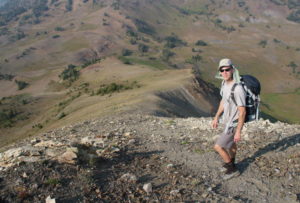 gravel and rocks and shoes with well worn tread, it was amply challenging. The slope dropped us down to the northeast corner of dollar lake right in time for wash up and dinner. This evening we were tired and the cold water we poured over our heads felt very good. Temperatures stayed warm throughout the evening and mosquitoes stayed more active–though still not nearly bad as some of our trips to Jefferson Park or Mt. Adams.
By morning we packed up to leave, all at once feeling less motivated to hike given the day started out in the 70’s and more motivated that we didn’t still want to be on the trail once it was in the 90’s. We hiked 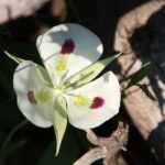 out the way we had come, surprised to see three parties of hikers on their way into the area about mid-day. It was well into the 90s as we reached the car and 101 by the time we reached Joseph. We savored our visit to Red Horse for lunch and were so disappointed that because the heat had become uncontrolled in their kitchen, they shut down all but the drinks. Ah, next time maybe? Leaving the area it was 108 by the time we passed through Enterprise and we were glad we called our return day when we did.
Why was it we reserved our time to hike in August? Next week we venture out again–but where? That decision will remain largely based on what is not on fire.